
Five Companies and NUAIR Begin Work on UTM Contingency Management
Brian Garrett-Glaser - Aviation Today • July 14, 2020
CAL Analytics leads $1.6M effort to tackle operational safety for commercial UAS

A team of companies received $1.6 million from the Federal Aviation Administration to build and test their Contingency Management Platform at the New York Unmanned Aircraft Systems (UAS) Test Site at Griffiss International Airport in Rome, New York.
Though much progress has been made toward creating and testing unmanned traffic management (UTM) systems that will enable safe integration of drones into the national airspace, little work has been done to identify and prepare for potential system faults outside of aircraft malfunctions.
That’s the task these five companies have set out conquer, led by CAL Analytics, which will also provide systems integration, and working with Northeast UAS Airspace Integration Research, or NUAIR. ResilienX is contributing health and usage monitoring and fault mitigation software; TruWeather is providing micro-weather services; Assured Information Security (AIS) is offering a cybersecurity module and Kongsberg Geospatial is providing beyond visual line of sight airspace visualization and mission management.
“We’re excited to work directly with the FAA to bring together some of the most innovative companies in the industry to tackle operational safety in UTM,” said Dr. Sean Calhoun, Managing Director of CAL Analytics, as reported by UAS Weekly. “Validating a contingency management approach is a critical, but often overlooked, step to achieve routine commercial drone operations.”
ResilienX’s health and integrity monitoring system, called FRAIHMWORK, performs both active and passive monitoring, according to Andrew Carter, president and CTO. Passive monitoring relies on safety-critical components and services of a UTM system reporting who they are, what they are doing, and if they think they are working correctly. Active monitoring entails diving into various sensor feeds and APIs to analyze data in near-real-time and determine whether the devices are functioning properly.
“In research performed in conjunction with the NASA and the FAA, the UTM industry has looked at some failure modes and has unintentionally run across others,” Carter told Avionics International. “Almost all of these fault scenarios, however, are focused on what happens when the drone does something unintended, due to a drone malfunction. As drones improve, and become more automated to autonomous, we believe that the data the drone is using to make decisions will need to be quality assured. We look at the UTM ecosystem and have seen almost no work done to date on failure modes or fault scenarios outside of drone malfunctions.”
The first goal of the project, Carter said, is to monitor for and detect these off-nominal conditions originating off the aircraft that could affect UAS operations. The second goal is to provide situational awareness of these scenarios and their impacts to a user who can then facilitate contingency management, either through automated responses or manual procedures, such as calling a UAS operator or air traffic control.
“Without an understanding of what can go wrong, how to detect it when it does, and what to do about it, the UTM ecosystem is missing many traits that are often considered in safety critical system of systems,” Carter said.
FAA officials speaking during the UAS Symposium earlier this month touted progress toward the deployment of UTM and reemphasize their intention to publish a final policy on remote identification by December.
Officials from the agency’s Aircraft Certification Office and Flight Standards Service — responsible for awarding aircraft certification and operational permits, respectively — noted the new challenges involved in approving drone operations, as each part of the equation impacts the other.
“The role of operational reduction of risk has increased significantly with the introduction of UAS," said Earl Lawrence, executive director of the FAA’s Flight Standards Service.
“[The Aircraft Certification Office] and Flight Standards Service have been a lot more connected in looking at the mitigations between certification and operational. Because there is a gap there that we’ve been working towards,” said Rick Domingo, executive director of the Aircraft Certification Office.
Missing from that discussion was the third dimension of risk mitigation: a system that exists outside of a particular drone or operational plan that exists to reduce risk.
In other words, UTM.
“To date, neither regulators, operators nor the UAS Traffic Management (UTM) industry has really figured this out,” Carter told Avionics. “UTM is largely a risk mitigation concept. The FAA opened up an avenue to address this in version 2 of their UTM CONOPS through a concept of Performance Authorizations. Until operators can take advantage UTM as a quantified risk mitigation, complex UAS operations will not be done at scale.”
Originally published by Aviation Today.
The milestone strengthens CAL’s AtlasAI platform for safer, scalable BVLOS drone operations under the FAA’s proposed Part 108 framework.
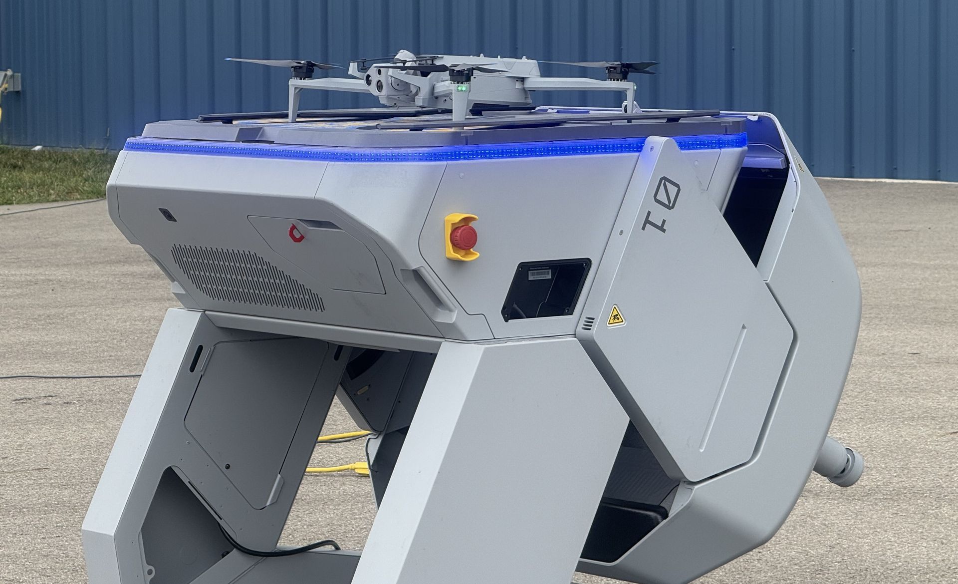
COLUMBUS, OH (February 9, 2026) — Ohio continues to lead the nation in modernizing emergency response with the selection of nine public safety agencies to participate in the Ohio Statewide Drone First Responder (DFR) Pilot Program , a first-of-its-kind initiative designed to expand rapid aerial response capabilities across communities of all sizes. The program, led by the Ohio Department of Transportation (ODOT) and DriveOhio, with program management support from SkyfireAI, reflects Ohio’s commitment to equipping first responders with innovative tools that improve situational awareness, enhance officer and responder safety, and reduce emergency response times. The following agencies have been selected to participate in the pilot program: City of Springfield Police/Fire/EMS Athens Police Department Lima Police Department Toledo Police Department Violet Township Fire/EMS Austintown Fire Department City of Hamilton Police/Fire/EMS Amherst Police Department Kelleys Island Fire/EMS Together, these agencies represent a diverse cross-section of Ohio, spanning urban centers, suburban communities, and rural jurisdictions — reinforcing the program’s goal of ensuring access to advanced emergency response capabilities statewide. Many of the selected agencies have also committed to sharing drone resources with neighboring jurisdictions, further expanding the impact of this program. “Ohio is committed to giving our first responders the tools they need to protect lives and serve their communities safely and effectively,” said Governor Mike DeWine . “This statewide Drone First Responder pilot reflects Ohio’s leadership in innovation, our strong partnership with local agencies, and our focus on using technology responsibly to support public safety across the state.” Created under Ohio House Bill 96, the Ohio Statewide DFR Pilot Program enables participating agencies to deploy state-approved, NDAA-compliant drone systems capable of rapid launch, real-time video streaming to command staff, and integration into Ohio’s emerging uncrewed aircraft traffic management framework, led by Ohio-based CAL Analytics. “We are enthusiastic supporters of DFR program and thankful for the efforts of so many Ohio leaders to accelerate this program into the execution phase,” said State Representative Adam Holmes , who championed the program's inclusion in the bill. “The DFR program will greatly enhance first responder effectiveness and will provide increased support for all Ohioans. A tremendous capability for our priceless first responders.” “Ohio is leading the way for the nation with the first statewide DFR program! Our ODOT leaders are setting the stage for an integrated network of DFR assets that will undoubtedly save lives and resources and be a force-multiplier for our undermanned first responder organizations,” said State Representative Bernard Willis , Chair of the House Transportation Committee. “In Ohio, the HOME of aviation we are the BEST at making historic innovations with flying machines, and we will NEVER stop leading the way!” With technology known as drone-in-a-box, a drone can be launched from a permanent docking site and be flown remotely to a scene. These pre-positioned drones provide real-time visual information to aid decision-making, and some can also drop critical medical supplies to the scene of an emergency. The program emphasizes operational readiness, standardized training, and responsible use, while maintaining a strong focus on community engagement and transparency. “This program is about thoughtful implementation, not experimentation,” said Richard Fox, Director of the DriveOhio UAS Center . "By coordinating procurement, training, and regulatory support at the state level, Ohio is creating a scalable model that benfits communities of every size. We're grateful for the confidence the legislature has in ODOT to execute this groundbreaking program." SkyfireAI, a national leader in public safety drone program development and FAA regulatory integration, is supporting the initiative as program manager, working closely with ODOT, DriveOhio, and participating agencies to ensure consistent standards and successful deployment. “The selection of these nine agencies reflects the strength of Ohio’s public safety community and the seriousness with which this program has been approached,” said Don Mathis, Co-Founder and CEO SkyfireAI . "This pilot lays the foundation for how states can responsibly scale DFR programs today — and prepare for future capabilities as technology continues to evolve." Selected agencies will participate in a structured onboarding process beginning in early 2026, including hands-on vendor demonstrations, training, and program coordination. Operations are expected to begin in Spring 2026 and continue for approximately a year. The pilot program will evaluate operational effectiveness, response outcomes, and opportunities for future expansion. Ohio’s Statewide Drone First Responder Pilot Program has already drawn national attention as a potential blueprint for other states seeking to modernize emergency response while maintaining strong governance, safety, and public trust. ### About CAL Analytics: CAL Analytics is a small business focusing on the development of aviation and autonomous systems. Located in Dayton, OH and founded in 2010, CAL has expertise in navigation systems, remote sensing, signal analysis, and information fusion. CAL is a leader in UAS Traffic Management (UTM) and Advanced Air Mobility (AAM) technology, offering airspace management, mission management, detect and avoid, and in-time system-wide safety assurance (ISSA) solutions. Our mission is to provide agile and rigorous approaches to bring new technologies to the world. More information at calanalytics.com About SkyfireAI: SkyfireAI is an AI-native drone technology company redefining mission-scale autonomy for public safety, defense, and enterprise markets. Our cloud-connected and edge-enabled software platform powers autonomous swarming, Beyond Visual Line of Sight (BVLOS) operations, and real-time AI analytics—unlocking faster response, smarter decision-making, and safer operations. Built for scalability, SkyfireAI’s solutions deliver repeatable, high-value outcomes across thousands of missions, positioning the company to capitalize on a rapidly expanding global uncrewed systems market projected to exceed $100 billion by 2030. More information is available at skyfireai.com . About ODOT’s DriveOhio Initiative: DriveOhio is the state’s center for smart mobility, advancing connected, automated, shared, and electric transportation. The UAS Center, located in Springfield, OH, is the statewide resource for uncrewed aircraft systems testing, integration, and operations.
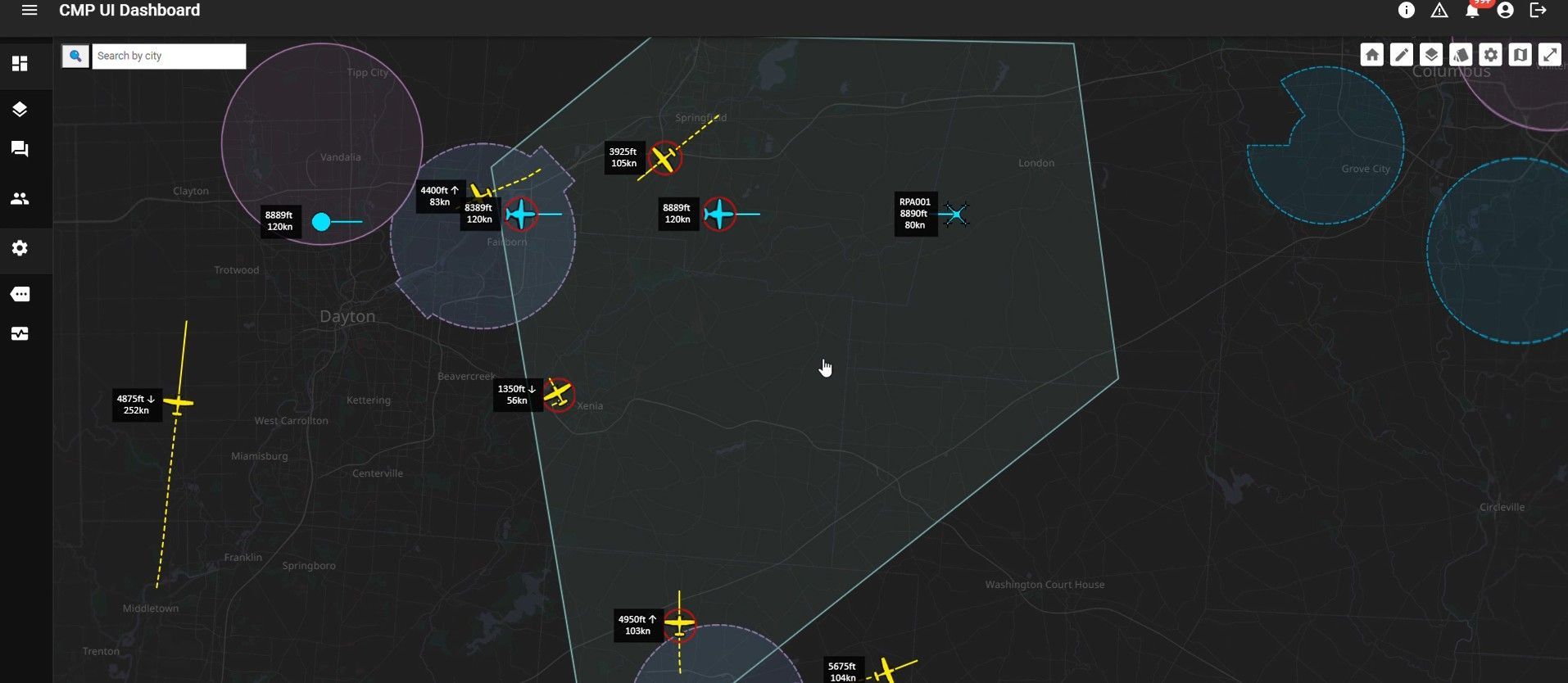
SPRINGFIELD, Ohio – January 27, 2026 – CAL Analytics, an innovator in advanced airspace management technologies, and AeroVironment, Inc. (“AV”) (NASDAQ: AVAV), a global defense technology leader delivering software-enabled disruptive autonomous systems, today announced the completed installation and initial operation of a new Beyond Visual Line of Sight (BVLOS) airspace management facility at the National Advanced Air Mobility Center of Excellence (NAAMCE) at Springfield-Beckley Municipal Airport in Springfield, Ohio. Initially developed under a Cooperative Research and Development Agreement (CRADA) between the Air Force Research Laboratory (AFRL) and the Ohio Department of Transportation (ODOT), the project now features an upgraded installation that integrates AV_Halo™ COMMAND, AV’s command and control (C2) architecture, with CAL Analytics’ Advanced Air Mobility (AAM) enterprise platform to establish the nation’s premiere test environment and management facility, where Department of War operators can safely conduct BVLOS missions in shared airspace utilizing existing Federal Aviation Administration (FAA) ground radar feeds. “This installation establishes the blueprint for how airports and states across the country can safely integrate uncrewed aircraft into existing airspace,” said Wahid Nawabi, Chairman, President and Chief Executive Officer at AV. “As the FAA defines the future of BVLOS rule-making, this facility provides the real-world operational data, safety validation, and interoperability framework regulators need. The system we’ve installed in Ohio isn’t just a mock-up or a test site — pending FAA approval it will be an operational and scalable model for nationwide deployment and the foundation for truly integrated air mobility.” The integration will support flight tests, evaluation, and day-to-day operations by routing AFRL’s access to the FAA’s ground-radar network through AV_Halo™ COMMAND — AV's modular, software-driven C2 architecture that fuses multiple enhanced sensor feeds, into a single, secure operating picture, giving operators continuous situational awareness for BVLOS mission planning and airspace safety. “AV_Halo is the connective tissue that turns a collection of sensors, radars, and platforms into a living, breathing airspace system,” said Stephen Lloyd, Senior Director C2, CUAS, and Tracking at AV. “By fusing FAA ground radar, and COTS surveillance sensors into a single, secure operating picture, AV_Halo delivers the assured visibility and machine-speed decision support needed for predictable BVLOS operations—and makes it possible to scale effortlessly from a single site to an entire statewide corridor.” When combined with CAL Analytics’ AAM enterprise platform, the system unifies radar and advanced DAA into a single real-time airspace view—enabling detect-and-avoid, extending autonomous BVLOS operations with precision and confidence. “Beyond Visual Line of Sight operations are the key to unlocking the next generation of air mobility,” said Dr. Sean Calhoun, Managing Director of CAL Analytics. “This facility will prove that BVLOS can be executed safely and reliably in shared airspace—and that matters because it sets the foundation for statewide corridors, national standards, and an entirely new layer of transportation infrastructure that will reshape how we move people, goods, data, and critical services across the country.” Pending full FAA approval, the facility will support local missions and real-time monitoring of UAS activity as AFRL, ODOT, the FAA, AV, and CAL Analytics collaborate to validate airspace-safety technologies, advance air-mobility corridors, drive economic development, and shape national BVLOS rules and integration standards. Plans are already underway to extend the system to enable corridors between Springfield and Columbus, Ohio, adding new radar sites and expanding detect-and-avoid coverage to support broader BVLOS operations across Ohio and additional sites nationwide.