
CAL ANALYTICS NEWS
CAL ANALYTICS NEWS
The milestone strengthens CAL’s AtlasAI platform for safer, scalable BVLOS drone operations under the FAA’s proposed Part 108 framework.
COLUMBUS, OH (February 9, 2026) — Ohio continues to lead the nation in modernizing emergency response with the selection of nine public safety agencies to participate in the Ohio Statewide Drone First Responder (DFR) Pilot Program , a first-of-its-kind initiative designed to expand rapid aerial response capabilities across communities of all sizes. The program, led by the Ohio Department of Transportation (ODOT) and DriveOhio, with program management support from SkyfireAI, reflects Ohio’s commitment to equipping first responders with innovative tools that improve situational awareness, enhance officer and responder safety, and reduce emergency response times. The following agencies have been selected to participate in the pilot program: City of Springfield Police/Fire/EMS Athens Police Department Lima Police Department Toledo Police Department Violet Township Fire/EMS Austintown Fire Department City of Hamilton Police/Fire/EMS Amherst Police Department Kelleys Island Fire/EMS Together, these agencies represent a diverse cross-section of Ohio, spanning urban centers, suburban communities, and rural jurisdictions — reinforcing the program’s goal of ensuring access to advanced emergency response capabilities statewide. Many of the selected agencies have also committed to sharing drone resources with neighboring jurisdictions, further expanding the impact of this program. “Ohio is committed to giving our first responders the tools they need to protect lives and serve their communities safely and effectively,” said Governor Mike DeWine . “This statewide Drone First Responder pilot reflects Ohio’s leadership in innovation, our strong partnership with local agencies, and our focus on using technology responsibly to support public safety across the state.” Created under Ohio House Bill 96, the Ohio Statewide DFR Pilot Program enables participating agencies to deploy state-approved, NDAA-compliant drone systems capable of rapid launch, real-time video streaming to command staff, and integration into Ohio’s emerging uncrewed aircraft traffic management framework, led by Ohio-based CAL Analytics. “We are enthusiastic supporters of DFR program and thankful for the efforts of so many Ohio leaders to accelerate this program into the execution phase,” said State Representative Adam Holmes , who championed the program's inclusion in the bill. “The DFR program will greatly enhance first responder effectiveness and will provide increased support for all Ohioans. A tremendous capability for our priceless first responders.” “Ohio is leading the way for the nation with the first statewide DFR program! Our ODOT leaders are setting the stage for an integrated network of DFR assets that will undoubtedly save lives and resources and be a force-multiplier for our undermanned first responder organizations,” said State Representative Bernard Willis , Chair of the House Transportation Committee. “In Ohio, the HOME of aviation we are the BEST at making historic innovations with flying machines, and we will NEVER stop leading the way!” With technology known as drone-in-a-box, a drone can be launched from a permanent docking site and be flown remotely to a scene. These pre-positioned drones provide real-time visual information to aid decision-making, and some can also drop critical medical supplies to the scene of an emergency. The program emphasizes operational readiness, standardized training, and responsible use, while maintaining a strong focus on community engagement and transparency. “This program is about thoughtful implementation, not experimentation,” said Richard Fox, Director of the DriveOhio UAS Center . "By coordinating procurement, training, and regulatory support at the state level, Ohio is creating a scalable model that benfits communities of every size. We're grateful for the confidence the legislature has in ODOT to execute this groundbreaking program." SkyfireAI, a national leader in public safety drone program development and FAA regulatory integration, is supporting the initiative as program manager, working closely with ODOT, DriveOhio, and participating agencies to ensure consistent standards and successful deployment. “The selection of these nine agencies reflects the strength of Ohio’s public safety community and the seriousness with which this program has been approached,” said Don Mathis, Co-Founder and CEO SkyfireAI . "This pilot lays the foundation for how states can responsibly scale DFR programs today — and prepare for future capabilities as technology continues to evolve." Selected agencies will participate in a structured onboarding process beginning in early 2026, including hands-on vendor demonstrations, training, and program coordination. Operations are expected to begin in Spring 2026 and continue for approximately a year. The pilot program will evaluate operational effectiveness, response outcomes, and opportunities for future expansion. Ohio’s Statewide Drone First Responder Pilot Program has already drawn national attention as a potential blueprint for other states seeking to modernize emergency response while maintaining strong governance, safety, and public trust. ### About CAL Analytics: CAL Analytics is a small business focusing on the development of aviation and autonomous systems. Located in Dayton, OH and founded in 2010, CAL has expertise in navigation systems, remote sensing, signal analysis, and information fusion. CAL is a leader in UAS Traffic Management (UTM) and Advanced Air Mobility (AAM) technology, offering airspace management, mission management, detect and avoid, and in-time system-wide safety assurance (ISSA) solutions. Our mission is to provide agile and rigorous approaches to bring new technologies to the world. More information at calanalytics.com About SkyfireAI: SkyfireAI is an AI-native drone technology company redefining mission-scale autonomy for public safety, defense, and enterprise markets. Our cloud-connected and edge-enabled software platform powers autonomous swarming, Beyond Visual Line of Sight (BVLOS) operations, and real-time AI analytics—unlocking faster response, smarter decision-making, and safer operations. Built for scalability, SkyfireAI’s solutions deliver repeatable, high-value outcomes across thousands of missions, positioning the company to capitalize on a rapidly expanding global uncrewed systems market projected to exceed $100 billion by 2030. More information is available at skyfireai.com . About ODOT’s DriveOhio Initiative: DriveOhio is the state’s center for smart mobility, advancing connected, automated, shared, and electric transportation. The UAS Center, located in Springfield, OH, is the statewide resource for uncrewed aircraft systems testing, integration, and operations.
SPRINGFIELD, Ohio – January 27, 2026 – CAL Analytics, an innovator in advanced airspace management technologies, and AeroVironment, Inc. (“AV”) (NASDAQ: AVAV), a global defense technology leader delivering software-enabled disruptive autonomous systems, today announced the completed installation and initial operation of a new Beyond Visual Line of Sight (BVLOS) airspace management facility at the National Advanced Air Mobility Center of Excellence (NAAMCE) at Springfield-Beckley Municipal Airport in Springfield, Ohio. Initially developed under a Cooperative Research and Development Agreement (CRADA) between the Air Force Research Laboratory (AFRL) and the Ohio Department of Transportation (ODOT), the project now features an upgraded installation that integrates AV_Halo™ COMMAND, AV’s command and control (C2) architecture, with CAL Analytics’ Advanced Air Mobility (AAM) enterprise platform to establish the nation’s premiere test environment and management facility, where Department of War operators can safely conduct BVLOS missions in shared airspace utilizing existing Federal Aviation Administration (FAA) ground radar feeds. “This installation establishes the blueprint for how airports and states across the country can safely integrate uncrewed aircraft into existing airspace,” said Wahid Nawabi, Chairman, President and Chief Executive Officer at AV. “As the FAA defines the future of BVLOS rule-making, this facility provides the real-world operational data, safety validation, and interoperability framework regulators need. The system we’ve installed in Ohio isn’t just a mock-up or a test site — pending FAA approval it will be an operational and scalable model for nationwide deployment and the foundation for truly integrated air mobility.” The integration will support flight tests, evaluation, and day-to-day operations by routing AFRL’s access to the FAA’s ground-radar network through AV_Halo™ COMMAND — AV's modular, software-driven C2 architecture that fuses multiple enhanced sensor feeds, into a single, secure operating picture, giving operators continuous situational awareness for BVLOS mission planning and airspace safety. “AV_Halo is the connective tissue that turns a collection of sensors, radars, and platforms into a living, breathing airspace system,” said Stephen Lloyd, Senior Director C2, CUAS, and Tracking at AV. “By fusing FAA ground radar, and COTS surveillance sensors into a single, secure operating picture, AV_Halo delivers the assured visibility and machine-speed decision support needed for predictable BVLOS operations—and makes it possible to scale effortlessly from a single site to an entire statewide corridor.” When combined with CAL Analytics’ AAM enterprise platform, the system unifies radar and advanced DAA into a single real-time airspace view—enabling detect-and-avoid, extending autonomous BVLOS operations with precision and confidence. “Beyond Visual Line of Sight operations are the key to unlocking the next generation of air mobility,” said Dr. Sean Calhoun, Managing Director of CAL Analytics. “This facility will prove that BVLOS can be executed safely and reliably in shared airspace—and that matters because it sets the foundation for statewide corridors, national standards, and an entirely new layer of transportation infrastructure that will reshape how we move people, goods, data, and critical services across the country.” Pending full FAA approval, the facility will support local missions and real-time monitoring of UAS activity as AFRL, ODOT, the FAA, AV, and CAL Analytics collaborate to validate airspace-safety technologies, advance air-mobility corridors, drive economic development, and shape national BVLOS rules and integration standards. Plans are already underway to extend the system to enable corridors between Springfield and Columbus, Ohio, adding new radar sites and expanding detect-and-avoid coverage to support broader BVLOS operations across Ohio and additional sites nationwide.

(DAYTON, Ohio) – CAL Analytics is pleased to announce a strategic partnership with AirData UAV to integrate the Low Altitude Authorization and Notification Capability (LAANC) into AirData’s suite of drone operation services. This collaboration streamlines operations and creates safety awareness for drone pilots by providing real-time airspace data and automated authorizations for flight in controlled airspace. AirData is committed to delivering an intuitive customer experience, with CAL’s LAANC service fully integrating into its existing fleet management platform. All AirData users can request LAANC authorizations through both the AirData web portal and the AirData mobile app. “This partnership with AirData marks a significant milestone for CAL Analytics,” said Dr. Sean Calhoun, Founder and Managing Director of CAL Analytics. “By integrating the LAANC capability into AirData’s already extensive software platform, we are able to offer AirData users a seamless LAANC authorization experience, enhancing both safety and efficiency in drone operations.” CAL is an FAA-approved UAS Service Supplier (USS) of LAANC, a collaborative effort between the Federal Aviation Administration (FAA) and industry partners, providing drone pilots with access to controlled airspace at or below 400 feet. This partnership with CAL will allow AirData users to quickly and efficiently obtain necessary flight authorizations, ensuring compliance and improving operational efficiency. “Providing intuitive and straightforward workflows for our customers is of paramount importance to us,” said AirData CEO Eran Steiner. “We are thrilled to partner with CAL Analytics to deliver best-in-class LAANC services. AirData is dedicated to offering our customers seamless and comprehensive drone fleet management, encompassing everything from mission planning and pilot certifications to compliance and flight data analysis. The LAANC integration for 3rd parties like AirData is another key component of CAL Analytics’ suite of UAS airspace management services, providing critical real-time data and automated processes that support safe and efficient drone operations. This partnership underscores CAL Analytics’ commitment to advancing the capabilities of UAS and promoting safe airspace practices. AirData’s collaboration with CAL will provide a streamlined LAANC workflow for users, allowing for quick and straightforward access from a variety of devices and locations. LAANC requests can be tied into AirData’s Mission Planning tool set and are recorded in the user’s account for compliance and record-keeping. The AirData platform provides a extensive set of features that benefit the entirety of the drone flight workflow, from pre-flight checklists to live video streaming during flights, with sophisticated post-flight fleet data analytics to maximize the value and safety of drone operations. This unified fleet management approach allows customers to mitigate risk, improve fleet efficiency, and manage end-to-end compliance. About CAL Analytics CAL Analytics is focused on the development of aviation and autonomous systems. Located in Dayton, OH and founded in 2010, CAL has expertise in navigation systems, remote sensing, signal analysis, and information fusion. CAL is a leader in UAS Traffic Management (UTM) and Advanced Air Mobility (AAM) technology, offering airspace management, mission management, detect and avoid, and in-time system-wide safety assurance (ISSA) solutions. Our mission is to provide agile and rigorous approaches to bring new technologies to the world. To learn more about CAL Analytics, please visit https://calanalytics.com/ About AirData AirData is the largest online drone fleet data management and real-time flight streaming platform, serving over 330,000 users with 42 million flights uploaded to date, capturing an average of 25,000 high-resolution flight records a day. AirData is used by large fleet operators around the world as a comprehensive flight safety data analysis and crash prevention platform, with advanced maintenance, mission planning, pilot tracking, and easy-to-use live streaming. To learn more about AirData, please visit https://airdata.com/

Dayton, Ohio –CAL Analytics announces it has been selected by AFWERX for a SBIR Direct-to-Phase II contract focused on building out, integrating, and testing an airspace surveillance and deconfliction technology for crewed and uncrewed aircraft of all sizes. This capability is critical to providing air traffic services for seamlessly integrating new aircraft types into the airspace for both permanent and tactical environments. In partnership with BlueHalo, the company transforming the future of global defense with market-leading solutions for command and control (C2) and airspace protection, CAL Analytics will use a combination of local and regional airspace surveillance feeds to verify the performance of the airspace surveillance tracking and deconfliction services. “Airspace surveillance tracking systems play an important role in Advanced Air Mobility (AAM) operations and are essential for providing DAA/deconfliction services to remotely piloted aircraft across many classes of airspace,” says Dr. Sean Calhoun of CAL Analytics. “These tracking systems ingest the various airspace surveillance sensors (ground radars, transponders, ADS-B, optical, etc.) and are required to correlate all the data from these sensors and provide a clean/fused airspace picture. To date, there is no tracking system in operational use that performs this function with the necessary plug-and-play capability required to support the true operationalization and scaling of AAM capabilities.” The Air Force Research Laboratory and AFWERX have partnered to streamline the Small Business Innovation Research (SBIR) and Small Business Technology Transfer (STTR) process by accelerating the small business experience through faster proposal to award timelines, changing the pool of potential applicants by expanding opportunities to small business and eliminating bureaucratic overhead by continually implementing process improvement changes in contract execution. The DAF began offering the Open Topic SBIR/STTR program in 2018 which expanded the range of innovations the DAF funded and now on June 12th, 2024, CAL Analytics will continue its journey to create and provide innovative capabilities that will strengthen the national defense of the United States of America. “The views expressed are those of the author and do not necessarily reflect the official policy or position of the Department of the Air Force, the Department of Defense, or the U.S. government.” About CAL Analytics CAL Analytics is a small business focusing on the development of aviation and autonomous systems. Located in Dayton, OH and founded in 2010, CAL has expertise in navigation systems, remote sensing, signal analysis, and information fusion. CAL is a leader in UAS Traffic Management (UTM) and Advanced Air Mobility (AAM) technology, offering airspace management, mission management, detect and avoid, and in-time system-wide safety assurance (ISSA) solutions. Our mission is to provide agile and rigorous approaches to bring new technologies to the world. About BlueHalo BlueHalo is purpose-built to provide industry-leading capabilities in the areas of Space, C-UAS and Autonomous Systems, Electronic Warfare & Cyber, and AI/ML. The company develops and brings to market next-generation capabilities to support customers’ critical missions and national security. Learn more at https://www.bluehalo.com and follow BlueHalo on LinkedIn . About AFRL The Air Force Research Laboratory is the primary scientific research and development center for the Department of the Air Force. AFRL plays an integral role in leading the discovery, development, and integration of affordable warfighting technologies for our air, space, and cyberspace force. With a workforce of more than 12,500 across nine technology areas and 40 other operations across the globe, AFRL provides a diverse portfolio of science and technology ranging from fundamental to advanced research and technology development. For more information, visit afresearchlab.com. About AFWERX As the innovation arm of the DAF and a directorate within the Air Force Research Laboratory, AFWERX brings cutting-edge American ingenuity from small businesses and start-ups to address the most pressing challenges of the DAF. AFWERX employs approximately 370 military, civilian and contractor personnel at five hubs and sites executing an annual $1.4 billion budget. Since 2019, AFWERX has executed over 6,200 new contracts worth more than $4.7 billion to strengthen the U.S. defense industrial base and drive faster technology transition to operational capability. For more information, visit: www.afwerx.com. Company Press Contact: Sean Calhoun, PhD Founder and Managing Director info@calanalytics.com
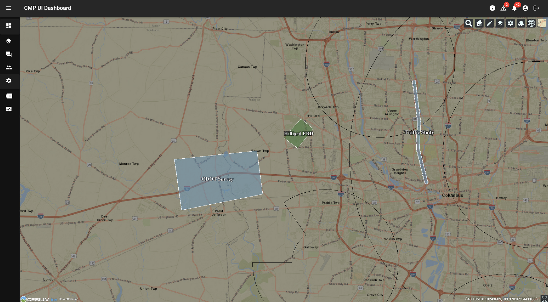
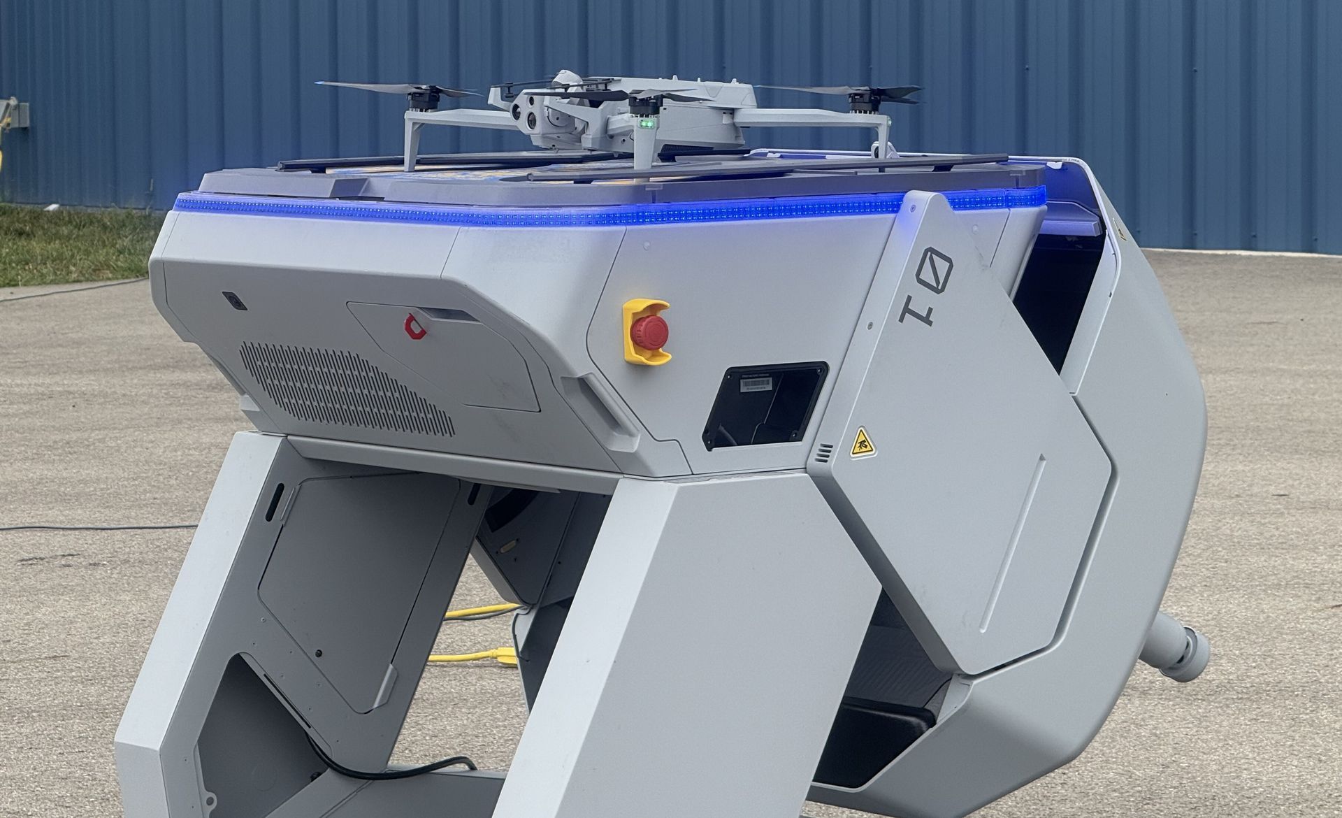
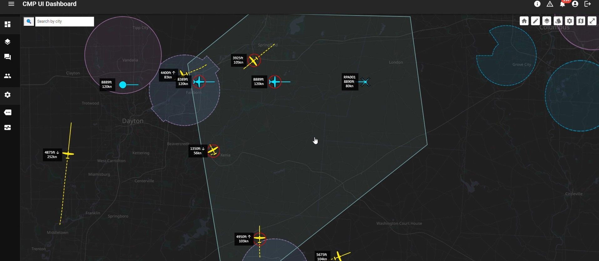
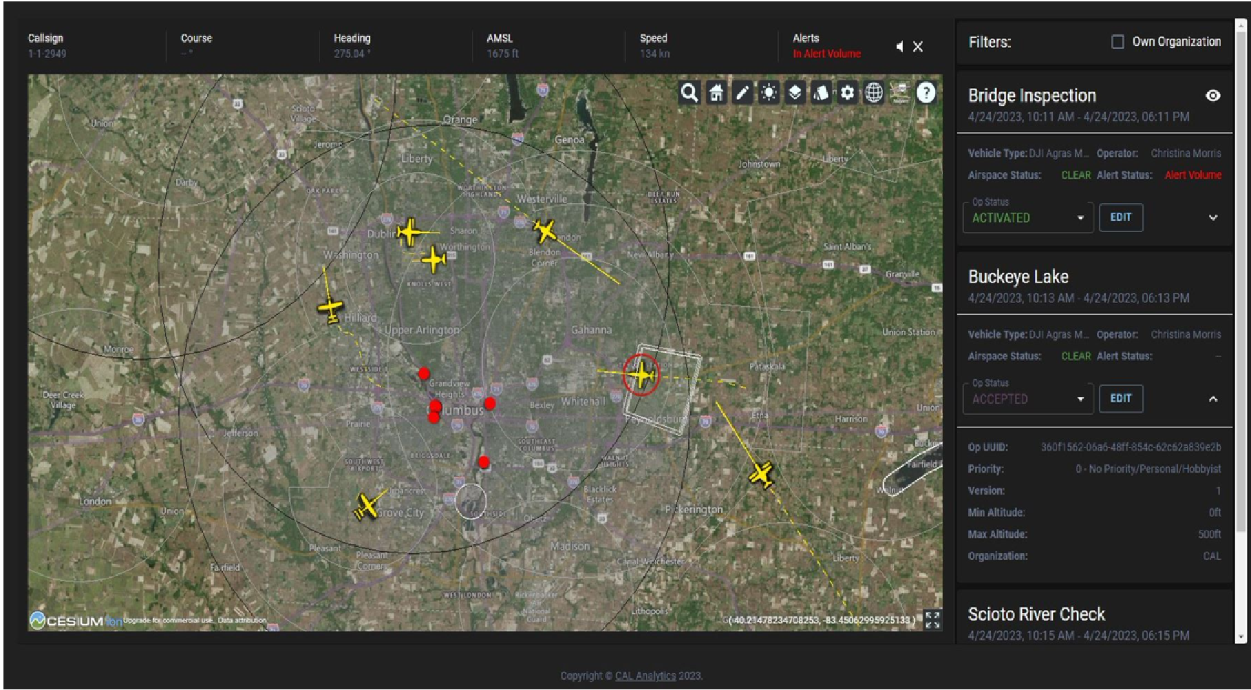
Columbus, OH – CAL Analytics, in coordination with the Ohio Department of Transportation (ODOT), has launched a low-altitude air traffic management system for drones to support statewide operations. As the number of uncrewed aircraft systems (UAS), or drones, grows, a robust system for managing the low-altitude airspace where these aircraft operate is necessary to ensure safety. While the Federal Aviation Administration (FAA) provides air traffic control for traditional aircraft flying in certain airspaces, low-altitude traffic management for drones is the responsibility of individual operators. Currently, drone pilots are required to keep the aircraft within sight to avoid a collision. A UAS Traffic Management (UTM) system enhances safety by enabling sharing of flight details between UAS operators, providing a digital tool for flight planning, and allowing operators to eventually operate beyond visual line of sight (BVLOS) while continuing to minimize the risk of collision. “The introduction of this vital capability continues Ohio’s tradition of innovation in the aviation community while prioritizing safety,” said Rich Fox, director of the Ohio UAS Center at ODOT. “As we collaborate with others at the newly opened National Advanced Air Mobility Center of Excellence, we expect this to be the first of many industry-leading activities coming out of that state-of-the-art facility.” Following several state sponsored research efforts to determine the best way to develop and deploy traffic management for uncrewed aircraft in Ohio, this system, implemented by CAL Analytics, provides interoperability where any user can enroll to share and receive flight information. As drone technology continues to advance, traffic management will be a key enabler of BVLOS operations, which currently require special permission from the FAA once stringent safety requirements are met. “We couldn’t be more thrilled to continue our collaboration with ODOT by deploying this discovery and synchronization services to fully realize this first of a kind operational UTM capability throughout the state of Ohio,” said Dr. Sean Calhoun, managing director of CAL Analytics. “This realization is the result of a lot of industry development, including the essential work from The Ohio State University research team and sponsored research from the Ohio Federal Research Network (OFRN). We are looking forward to working with the various interested stakeholders throughout the state and the FAA to learn from this system and to start scaling UAS operations throughout Ohio.” ODOT and the City of Hilliard will be the first organizations to enroll in the system and begin exchanging information as they look to leverage UAS as a tool for everything from inspection and traffic monitoring to onsite situational awareness for first responders, such as police and fire department dispatches. “Hilliard is excited to leverage this and other airspace services that Ohio has established to enable our first responder drone operations” says Deputy Police Chief for Hilliard, Ron Clark. “These services will be critical for us to achieve FAA approval and operate our drones in a safe and effective manner.” In the coming years, more advanced and BVLOS drone operations will increase in Ohio, which means multiple operators may be flying in the same area to deliver medical supplies, perform emergency services, conduct infrastructure inspections, and even deliver commercial packages. For safe and successful scaling of commercial drone operations, it’s imperative that pilots have situational awareness for strategic deconfliction. While both private and public organizations can enroll in the traffic management system, this resource is particularly valuable for other state agencies and local governments across Ohio. These services are available at no cost to any operator or fleet manager that requests access and goes through the onboarding process. To learn more or request access, please contact CAL Analytics at info@calanalytics.com.
Columbus, OH – CAL Analytics has been selected by the Ohio Department of Transportation (ODOT) to provide statewide Uncrewed Aircraft System (UAS) operation services using CAL’s UAS Service Supplier (USS) platform. This agreement is the culmination of a multi-year build-up of CAL’s UTM service platform that started in 2019 with a $1.4M award from the Ohio Federal Research Network (OFRN) to develop an interoperable and resilient contingency management system for Ohio UAS Operations. Through this work, Ohio continues its leadership in the innovation, research, development and utilization of UAS technology. CAL’s USS will provide ODOT a wide array of services, including a centralized monitoring and management capability of statewide infrastructure, such as communications, navigation and airspace surveillance equipment, critical for UAS Beyond Visual Line-of-Sight operations. Additionally, CAL will provide ODOT with enhanced operational planning and situational awareness for its extensive statewide utilization of UAS for Visual Line-of-Sight operations. “Ohio and ODOT in particular, has been on the forefront of embracing UAS technology, so we are very excited to have our USS platform provide the basis for statewide utilization,” said Dr. Sean Calhoun, Managing Director of CAL Analytics. “We have put a lot of our system development focus making sure our platform provides a host of performance and safety related features. Our work with NASA and integrating our health and integrity monitoring capabilities into our deployments will ensure statewide systems can scale in a robust and safe way.” “CAL Analytics technology will help us take support of our uncrewed aircraft operations to the next level. Not only will our remote pilots use it for situational awareness and safety, but we are exploring the ability to expand this service to first responders across the state to better coordinate air support during an emergency,” said Rich Fox, UAS Director – Ohio UAS Center for ODOT. This agreement between CAL Analytics and the Ohio Department of Transportation is big win for the State of Ohio and the state of UAS ecosystem growth. Ohio is a leader in the Advanced Air Mobility business development aspect of UAS operations and the individuals involved in the OFRN are proud to have played a part in supporting new technology and innovation development,” said Maj Gen (Ret.) Mark Bartman, OFRN Program Executive for Parallax Advanced Research.
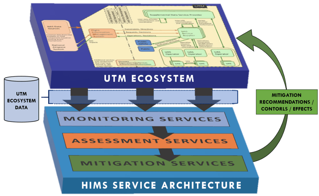
Columbus, OH – CAL Analytics has been awarded a NASA Phase II-E Small Business Innovation Research (SBIR) award to deploy their Health & Integrity System (HIMS) to the Ohio Department of Transportation’s Uncrewed Traffic Management (UTM) system. This will be the first-time an In-time System-wide Safety Assurance (ISSA) system will be deployed and integrated into a functioning UTM environment for operations in an urban environment. This initiative is researching ways in which the resiliency and robustness of UTM ecosystems can and should be improved. The primary result of those activities was the formulation of a flexible, service-based architecture for Health & Integrity (H&I) monitoring, assessment, and mitigation of complex, federated System of Systems (SoS). This aptly named Health & Integrity Management System (HIMS) adds another dimension of capability to the UTM architecture wherein it is intended to holistically monitor and respond to the ecosystem, providing continuity between independent UTM services from a system reliability perspective “Being able to evaluate our ISSA implementation in an operational environment that Ohio offers will be a critical step for validating the our various HIMS safety monitors and system interactions what will be key to ensuring a robust UTM ecosystem for safe low-altitude operations,” said Dr. Sean Calhoun, Managing Director of CAL Analytics. “Our HIMS system not only provides various real-time monitoring of key systems, such as surveillance and navigation, but we also provide capabilities assessing the impacts to operations and how to relay that information to operators.” The CAL HIMS system builds off the Resilienx, Inc. FRAIHMWORK platform to realize a scalable ISSA system tailored specifically to UTM applications. The open architecture approach to the ISSA system enables seamless integration of future system monitoring and scalability. The effort builds off Ohio and NASA’s existing AAM National Campaign partnership, which includes System-Wide Safety, and The Ohio State Universities UTM development effort sponsored by the Ohio Department of Transportation (ODOT). “Safety is the number one goal at the Ohio Department of Transportation, operational assurance is the most important component in any aviation operation. As we continue to move towards highly automated and remote operations in the airspace, the health of systems and sensors providing information becomes crucial to maintain the safety for transportation on the ground and in the air,” said Fred Judson, UAS Director – Ohio UAS Center for ODOT. “Safety is the key to innovation in aviation. Learning how and when to automate our safety monitoring, assessment, and mitigation functions enables us to design air systems that benefit all of us.” said Dr. Misty Davies, NASA’s Project Manager for System-Wide Safety Project.

(SYRACUSE, NEW YORK) – CAL Analytics is deploying their detect and avoid (DAA) service and contingency management platform (CMP) within New York’s 50-mile Drone Corridor and Federal Aviation Administration (FAA) designated uncrewed aircraft systems (UAS) Test Site at Griffiss International Airport, managed by NUAIR. The organizations are working jointly on a Technical Assistance program with the FAA to enable and approve a DAA service for low-altitude beyond visual line of sight (BVLOS) UAS operations. Current regulations require drone operators to always have a pair of human eyes visually monitoring the airspace in which the drone is flying, limiting the ability to fly long distances. Without being able to see the drone, the system needs the ability to detect and avoid obstacles in the air and on ground to assure the safety of both crewed and uncrewed aircraft. The ability to safely fly BVLOS is the key to unlocking the full potential and economic advantage of routine commercial drone operations like medical and package deliveries. “This upgrade to the 50-mile Drone Corridor between Rome and Syracuse will help integrate detect and avoid technology to further the safe advancement of unmanned aircraft systems into the national airspace and unlock the true potential of commercial drone operations,” said Oneida County Executive Anthony J. Picente Jr. “We look forward to the fruit this partnership between CAL Analytics and the FAA will bear at Oneida County’s Test Site, which continues to flourish under NUAIR’s management.” The DAA service will be CAL’s newest UAS traffic management (UTM) service being brought to market and builds off their existing contingency management platform (CMP), which provides a suite of UTM services. CAL’s CMP will offer critical airspace services, including situational awareness from Kongsberg, conflict detection from CAL, health monitoring by ResilienX, and various weather services from TruWeather Solutions to help ensure the safe operation of uncrewed aircraft. “We’re excited to partner with NUAIR and working directly with the FAA to get our DAA service approved for small UAS,” said Dr. Sean Calhoun, managing director of CAL Analytics. “This will go a long way towards validating several of the DAA standards, including those from ASTM-F38 and RTCA SC-147, and opening the skies for safe BVLOS drone operations.” The BVLOS flight operations will be performed by NUAIR who manages operations of the New York UAS Test Site at Griffiss International Airport in Rome, NY, one of just seven FAA-designated UAS test sites in the United States. The CAL technology will provide several key services to enabling safe BVLOS operations within New York’s 50-mile UAS Corridor instrumented with radar, communication networks, including 5G, and other leading-edge technologies that facilitate advanced drone operations. “One of the most important recommendations from the recent BVLOS Aviation Rulemaking Committee was for the FAA to develop a methodology for approving safety-critical UTM services for BVLOS,” said NUAIR Chief Technology Officer Andy Thurling. “NUAIR is working with our partners at CAL Analytics and the FAA to do just that.” NUAIR and its alliance of partners, including CAL Analytics, ResilienX, TruWeather Solutions and more will be showcasing their technologies and latest advancements at the upcoming AUVSI XPONENTIAL conference in Orlando, Florida, April 25-28. The companies are part of the GENIUS NY booth #1761, highlighting leading-edge companies in Central New York and taking applications for the next round of the $3 million business acceleration competition that is GENIUS NY. ### About NUAIR NUAIR (Northeast UAS Airspace Integration Research Alliance, Inc.) is a New York-based nonprofit with a mission to safely integrate uncrewed aircraft systems (UAS) into the national airspace, enabling scalable, economically viable commercial drone operations. NUAIR manages operations of the FAA-designated New York UAS Test Site at Griffiss International Airport, Rome, NY on behalf of Oneida County and is responsible for the advancement of New York’s 50-mile UAS Corridor between Rome and Syracuse, NY. https://nuair.org

CAL Analytics Part of Team Developing Framework for Statewide Strategy