
FlyOhio to Partner with NASA in Deployment of Ohio's Advanced Air Mobility Ecosystem
Ohio Department of Transportation • May 17, 2021
CAL Analytics Part of Team Developing Framework for Statewide Strategy

COLUMBUS - FlyOhio, a collaboration of public, private and academic institutions led by DriveOhio’s advanced air mobility (AAM) group, has been selected to participate in the National Aeronautics and Space Administration (NASA)’s Advanced Air Mobility National Campaign. The award focuses on system development through integrated vehicle and airspace demonstrations in real-world scenarios that are critical to safe and effective commercialization.
“In Ohio, we have a longstanding history with advancing aerospace technology, and we continue to pursue new opportunities to support the development of cutting-edge technology,” said Governor DeWine. “We are eager to join with NASA in a new, broad coalition of institutions across the state who are investing in the advancement of this transformative aerospace technology.”
Building upon Ohio’s ground-breaking work in “beyond-line-of-sight” drone systems and SkyVision
work at Springfield-Beckley Airport and leveraging relationships established through the U.S. Air Force’s Agility Prime program, FlyOhio’s project will incorporate multiple use cases for personal travel and delivery of goods across the State of Ohio. The FlyOhio team is comprised of key aircraft manufacturers, operators, and airspace service providers and suppliers, as well as Ohio regional and city planning organizations, local stakeholders, academic institutions, and health care networks.
The multiyear program lays out an innovative framework to design, test and deploy a statewide AAM strategy focused on the movement of people and goods. Specifically, the winning proposal outlines test applications in health care delivery, air taxi or air metro, and regional air cargo transport.
The program’s development will be supported by the FlyOhio AAM Economic Impact Study due to be released June 6, 2021. A unique research effort to forecast the potential economic impacts of urban and regional air mobility, the report provides data on Ohio’s major urban centers and air corridors connecting its largest cities to rural communities. Also, the report examines Ohio’s advanced aviation infrastructure needs, revenue potential, and prospective job growth, among other economic indicators.
“Advanced Air Mobility technology is revolutionizing the transportation industry and Ohio is well positioned to lead market adoption as these solutions scale. At DriveOhio, we are committed to developing and deploying connected, automated, shared, and electric vehicles and infrastructure on the ground and in the air. This program is a manifestation of that ethos, and we are excited to increase the advanced aviation investment in Ohio’s economy,” said Howard Wood, executive director at DriveOhio.
Home to more than 550 aerospace companies and three of the nation’s premier aerospace centers— NASA Glenn Research Center, NASA Plum Brook Station and Air Force Research Laboratory (AFRL) at Wright Patterson Air Force Base—Ohio is the nation’s largest aerospace industry supplier, with a workforce of more than 38,000 in the aviation and aerospace industry.
“JobsOhio is focused on accelerating Ohio’s economic growth and our partnership with FlyOhio and NASA will help to fulfill this mission,” said J.P. Nauseef, JobsOhio president and CEO. “Ohio’s economy has strong momentum as it emerges from the pandemic, and this powerful industry coalition is more evidence that Ohio is becoming the go-to spot in the Midwest for some of America’s top innovators. This campaign further positions Ohio’s multi-billion-dollar mobility economy to compete in this fast-growing and dynamic industry sector.”
About FlyOhio:
An initiative of DriveOhio, FlyOhio
operates out of the Ohio Unmanned Aerial Systems (UAS) Center and seeks to make Ohio airspace among the first in the nation ready to fly beyond line of sight. FlyOhio works with public, private, and academic partners to develop, test, and deploy the technology needed for drones to safely fly long distances without fear of collision, ultimately bringing the use of unmanned aircraft for freight, package, and personal transportation closer to reality.
Campaign Partners:
Industry
ANRA Technologies
Cal Analytics/ResilienX
Columbus Regional Airport Authority
Central Ohio Transit Authority (COTA)
Kitty Hawk
Moog
OneSky Systems, Inc.
Reliable Robotics
United Airlines
VyrtX
Flight Profiler, LLC
Academia and Research
Air Force Research Laboratory
Cincinnati Children's Hospital Medical Center
Center of Science and Industry (COSI)
Cleveland Clinic
MedFlight of Ohio
Ohio Aerospace Institute
Ohio Federal Research Network
Ohio University
The Ohio State University
University of Cincinnati
Economic Development
JobsOhio
Dayton Development Coalition
Ohio Southeast
One Columbus
REDI Cincinnati
Regional Growth Partnership
Team NEO
Metropolitan Planning
Miami Valley Regional Planning Commission
Mid-Ohio Regional Planning Commission
OKI Regional Council of Governments
***
Original post
by Ohio Department of Transportation.
The milestone strengthens CAL’s AtlasAI platform for safer, scalable BVLOS drone operations under the FAA’s proposed Part 108 framework.
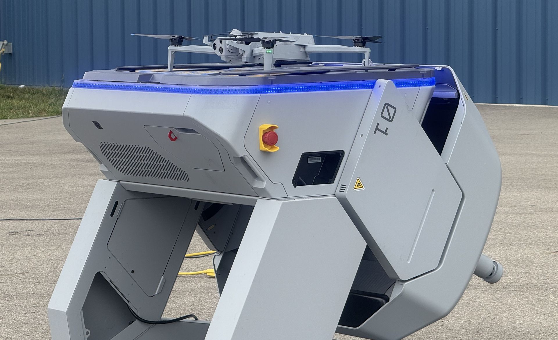
COLUMBUS, OH (February 9, 2026) — Ohio continues to lead the nation in modernizing emergency response with the selection of nine public safety agencies to participate in the Ohio Statewide Drone First Responder (DFR) Pilot Program , a first-of-its-kind initiative designed to expand rapid aerial response capabilities across communities of all sizes. The program, led by the Ohio Department of Transportation (ODOT) and DriveOhio, with program management support from SkyfireAI, reflects Ohio’s commitment to equipping first responders with innovative tools that improve situational awareness, enhance officer and responder safety, and reduce emergency response times. The following agencies have been selected to participate in the pilot program: City of Springfield Police/Fire/EMS Athens Police Department Lima Police Department Toledo Police Department Violet Township Fire/EMS Austintown Fire Department City of Hamilton Police/Fire/EMS Amherst Police Department Kelleys Island Fire/EMS Together, these agencies represent a diverse cross-section of Ohio, spanning urban centers, suburban communities, and rural jurisdictions — reinforcing the program’s goal of ensuring access to advanced emergency response capabilities statewide. Many of the selected agencies have also committed to sharing drone resources with neighboring jurisdictions, further expanding the impact of this program. “Ohio is committed to giving our first responders the tools they need to protect lives and serve their communities safely and effectively,” said Governor Mike DeWine . “This statewide Drone First Responder pilot reflects Ohio’s leadership in innovation, our strong partnership with local agencies, and our focus on using technology responsibly to support public safety across the state.” Created under Ohio House Bill 96, the Ohio Statewide DFR Pilot Program enables participating agencies to deploy state-approved, NDAA-compliant drone systems capable of rapid launch, real-time video streaming to command staff, and integration into Ohio’s emerging uncrewed aircraft traffic management framework, led by Ohio-based CAL Analytics. “We are enthusiastic supporters of DFR program and thankful for the efforts of so many Ohio leaders to accelerate this program into the execution phase,” said State Representative Adam Holmes , who championed the program's inclusion in the bill. “The DFR program will greatly enhance first responder effectiveness and will provide increased support for all Ohioans. A tremendous capability for our priceless first responders.” “Ohio is leading the way for the nation with the first statewide DFR program! Our ODOT leaders are setting the stage for an integrated network of DFR assets that will undoubtedly save lives and resources and be a force-multiplier for our undermanned first responder organizations,” said State Representative Bernard Willis , Chair of the House Transportation Committee. “In Ohio, the HOME of aviation we are the BEST at making historic innovations with flying machines, and we will NEVER stop leading the way!” With technology known as drone-in-a-box, a drone can be launched from a permanent docking site and be flown remotely to a scene. These pre-positioned drones provide real-time visual information to aid decision-making, and some can also drop critical medical supplies to the scene of an emergency. The program emphasizes operational readiness, standardized training, and responsible use, while maintaining a strong focus on community engagement and transparency. “This program is about thoughtful implementation, not experimentation,” said Richard Fox, Director of the DriveOhio UAS Center . "By coordinating procurement, training, and regulatory support at the state level, Ohio is creating a scalable model that benfits communities of every size. We're grateful for the confidence the legislature has in ODOT to execute this groundbreaking program." SkyfireAI, a national leader in public safety drone program development and FAA regulatory integration, is supporting the initiative as program manager, working closely with ODOT, DriveOhio, and participating agencies to ensure consistent standards and successful deployment. “The selection of these nine agencies reflects the strength of Ohio’s public safety community and the seriousness with which this program has been approached,” said Don Mathis, Co-Founder and CEO SkyfireAI . "This pilot lays the foundation for how states can responsibly scale DFR programs today — and prepare for future capabilities as technology continues to evolve." Selected agencies will participate in a structured onboarding process beginning in early 2026, including hands-on vendor demonstrations, training, and program coordination. Operations are expected to begin in Spring 2026 and continue for approximately a year. The pilot program will evaluate operational effectiveness, response outcomes, and opportunities for future expansion. Ohio’s Statewide Drone First Responder Pilot Program has already drawn national attention as a potential blueprint for other states seeking to modernize emergency response while maintaining strong governance, safety, and public trust. ### About CAL Analytics: CAL Analytics is a small business focusing on the development of aviation and autonomous systems. Located in Dayton, OH and founded in 2010, CAL has expertise in navigation systems, remote sensing, signal analysis, and information fusion. CAL is a leader in UAS Traffic Management (UTM) and Advanced Air Mobility (AAM) technology, offering airspace management, mission management, detect and avoid, and in-time system-wide safety assurance (ISSA) solutions. Our mission is to provide agile and rigorous approaches to bring new technologies to the world. More information at calanalytics.com About SkyfireAI: SkyfireAI is an AI-native drone technology company redefining mission-scale autonomy for public safety, defense, and enterprise markets. Our cloud-connected and edge-enabled software platform powers autonomous swarming, Beyond Visual Line of Sight (BVLOS) operations, and real-time AI analytics—unlocking faster response, smarter decision-making, and safer operations. Built for scalability, SkyfireAI’s solutions deliver repeatable, high-value outcomes across thousands of missions, positioning the company to capitalize on a rapidly expanding global uncrewed systems market projected to exceed $100 billion by 2030. More information is available at skyfireai.com . About ODOT’s DriveOhio Initiative: DriveOhio is the state’s center for smart mobility, advancing connected, automated, shared, and electric transportation. The UAS Center, located in Springfield, OH, is the statewide resource for uncrewed aircraft systems testing, integration, and operations.
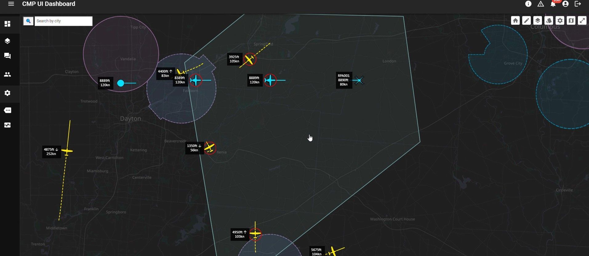
SPRINGFIELD, Ohio – January 27, 2026 – CAL Analytics, an innovator in advanced airspace management technologies, and AeroVironment, Inc. (“AV”) (NASDAQ: AVAV), a global defense technology leader delivering software-enabled disruptive autonomous systems, today announced the completed installation and initial operation of a new Beyond Visual Line of Sight (BVLOS) airspace management facility at the National Advanced Air Mobility Center of Excellence (NAAMCE) at Springfield-Beckley Municipal Airport in Springfield, Ohio. Initially developed under a Cooperative Research and Development Agreement (CRADA) between the Air Force Research Laboratory (AFRL) and the Ohio Department of Transportation (ODOT), the project now features an upgraded installation that integrates AV_Halo™ COMMAND, AV’s command and control (C2) architecture, with CAL Analytics’ Advanced Air Mobility (AAM) enterprise platform to establish the nation’s premiere test environment and management facility, where Department of War operators can safely conduct BVLOS missions in shared airspace utilizing existing Federal Aviation Administration (FAA) ground radar feeds. “This installation establishes the blueprint for how airports and states across the country can safely integrate uncrewed aircraft into existing airspace,” said Wahid Nawabi, Chairman, President and Chief Executive Officer at AV. “As the FAA defines the future of BVLOS rule-making, this facility provides the real-world operational data, safety validation, and interoperability framework regulators need. The system we’ve installed in Ohio isn’t just a mock-up or a test site — pending FAA approval it will be an operational and scalable model for nationwide deployment and the foundation for truly integrated air mobility.” The integration will support flight tests, evaluation, and day-to-day operations by routing AFRL’s access to the FAA’s ground-radar network through AV_Halo™ COMMAND — AV's modular, software-driven C2 architecture that fuses multiple enhanced sensor feeds, into a single, secure operating picture, giving operators continuous situational awareness for BVLOS mission planning and airspace safety. “AV_Halo is the connective tissue that turns a collection of sensors, radars, and platforms into a living, breathing airspace system,” said Stephen Lloyd, Senior Director C2, CUAS, and Tracking at AV. “By fusing FAA ground radar, and COTS surveillance sensors into a single, secure operating picture, AV_Halo delivers the assured visibility and machine-speed decision support needed for predictable BVLOS operations—and makes it possible to scale effortlessly from a single site to an entire statewide corridor.” When combined with CAL Analytics’ AAM enterprise platform, the system unifies radar and advanced DAA into a single real-time airspace view—enabling detect-and-avoid, extending autonomous BVLOS operations with precision and confidence. “Beyond Visual Line of Sight operations are the key to unlocking the next generation of air mobility,” said Dr. Sean Calhoun, Managing Director of CAL Analytics. “This facility will prove that BVLOS can be executed safely and reliably in shared airspace—and that matters because it sets the foundation for statewide corridors, national standards, and an entirely new layer of transportation infrastructure that will reshape how we move people, goods, data, and critical services across the country.” Pending full FAA approval, the facility will support local missions and real-time monitoring of UAS activity as AFRL, ODOT, the FAA, AV, and CAL Analytics collaborate to validate airspace-safety technologies, advance air-mobility corridors, drive economic development, and shape national BVLOS rules and integration standards. Plans are already underway to extend the system to enable corridors between Springfield and Columbus, Ohio, adding new radar sites and expanding detect-and-avoid coverage to support broader BVLOS operations across Ohio and additional sites nationwide.