Ohio Selects Team for Unmanned Aerial Systems Traffic Management Contract

Katherine Jerome • March 26, 2020

CAL Analytics Leads Drone Companies & Ohio Universities Partner to Win Milestone Project

Beavercreek, OH – CAL Analytics recently secured a $1.4M contract with the Ohio Federal Research Network (OFRN) to lead the development of a contingency management platform (CMP) for beyond visual line of sight drone operations. Interoperability, Resiliency and Contingency Management for Ohio UAS Operations is one of six projects awarded in round four of OFRN’s Sustaining Ohio Aeronautical Readiness and Innovation Next Generation (SOARING) initiative. The collaborative effort brings together private companies--ResilienX, TruWeather Solutions, Kongsberg Geospatial, with higher education partners-- Kent State University, and The Ohio State University.

OFRN is a program of the Wright State Applied Research Corporation, and has the mission to stimulate Ohio’s innovation economy through job and product creation by building statewide collaborations between university researchers, Ohio-based federal laboratories and businesses. OFRN’s SOARING initiative leverages funding from Ohio’s unique aerospace assets in overcoming critical technical barriers and business challenges to enable more widespread adoption of UAS into the national airspace.

As the prime contractor, CAL Analytics will lead system integration on the ground in Ohio, deploying the CMP to two customers: the Ohio Department of Transportation in Columbus, and the Air Force Research Lab in Springfield.

“We are really excited about this project, as it will start layering in some of the safety measures and procedures that are critical to operationalize routine UAS operations,” said Sean Calhoun, managing director of CAL Analytics and project lead. “We think this project will put a nice spotlight on Ohio and all the great UAS development work that is happening here.”

ResilienX, will contribute its proprietary software tool, FRAIHMWORK, that provides a robust health and integrity monitoring platform to ensure the safety and resiliency of networked systems.

From our experience working with drones in the national air space, we know there are two difficult questions that the industry will have to answer: How do you know everything is working correctly? And, what do you do when something goes wrong? Deploying our CMP in Ohio is the first step to answering these important questions for this burgeoning industry,” said Andrew Carter, president & CTO of ResilienX.

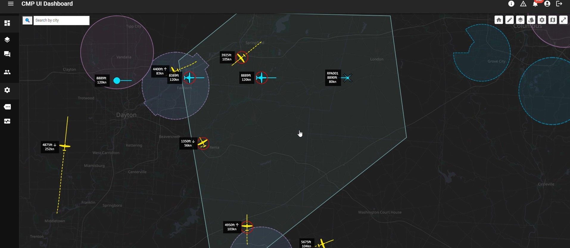
Geospatial software company, Kongsberg Geospatial , will contribute IRIS UxS: a real-time airspace visualization system for Beyond Visual Line-of-Sight (BVLOS) mission management that allows a single operator to manage multiple aircraft. The system combines live data from a variety of sensors to create a real-time picture of the airspace where UAS are being operated.

“For the past few years, we’ve been working on improving safety for BVLOS UAS missions through the development of IRIS UxS,” said Company Vice President, Paige Cutland. “The IRIS system is now actively deployed for a variety of long-range mission applications including drone delivery, pipeline inspection and emergency airspace operations.”

TruWeather Solutions will deploy its dynamic platform that collects and presents real-time, predictive micro-weather analytics and insights.

"Our goal is to be the best UAS weather service in the world,” said Don Berchoff, CEO of TruWeather. “To be the best in a data-centric business, your data better be as accurate as possible, trusted and reliable. Our collaboration with Ohio will raise TruWeather to the forefront as a data-trusted micro-weather service to keep people on the ground safe and airframes productive."

The project also includes two Ohio-based universities. Kent State brings extensive knowledge of air traffic control (ATC) and the national airspace.

“We will be using our state-of-the-art ATC Simulator to test BVLOS capabilities and interaction of UAS Traffic Management with the current ATC infrastructure,” said Jenna Merriman, a lecturer with the University. “We are most excited to be a part of a project that could help in the architecture of UAS airspace.”

Ohio State was selected for its expertise in resilience engineering and human-autonomy teaming.

Dr. Martijn IJtsma, assistant-professor at OSU ’s Integrated Systems Engineering department said, “OSU has a long and successful track record studying resilience in complex, safety-critical systems. One of the challenges for contingency management in UTM is to design the system and

its operations to support fluent coordination and adaptation between multiple distributed actors. We use modeling and simulation techniques to identify how we can support joint activity during edge case scenarios and make recommendations for creating a resilient UTM system.”

The project is a few weeks into the 18-month period of performance and is expected to wrap up during the summer of 2021 with final demonstrations to take place in both Springfield and Columbus, Ohio.

By Sean Calhoun January 28, 2026
SPRINGFIELD, Ohio – January 27, 2026 – CAL Analytics, an innovator in advanced airspace management technologies, and AeroVironment, Inc. (“AV”) (NASDAQ: AVAV), a global defense technology leader delivering software-enabled disruptive autonomous systems, today announced the completed installation and initial operation of a new Beyond Visual Line of Sight (BVLOS) airspace management facility at the National Advanced Air Mobility Center of Excellence (NAAMCE) at Springfield-Beckley Municipal Airport in Springfield, Ohio. Initially developed under a Cooperative Research and Development Agreement (CRADA) between the Air Force Research Laboratory (AFRL) and the Ohio Department of Transportation (ODOT), the project now features an upgraded installation that integrates AV_Halo™ COMMAND, AV’s command and control (C2) architecture, with CAL Analytics’ Advanced Air Mobility (AAM) enterprise platform to establish the nation’s premiere test environment and management facility, where Department of War operators can safely conduct BVLOS missions in shared airspace utilizing existing Federal Aviation Administration (FAA) ground radar feeds. “This installation establishes the blueprint for how airports and states across the country can safely integrate uncrewed aircraft into existing airspace,” said Wahid Nawabi, Chairman, President and Chief Executive Officer at AV. “As the FAA defines the future of BVLOS rule-making, this facility provides the real-world operational data, safety validation, and interoperability framework regulators need. The system we’ve installed in Ohio isn’t just a mock-up or a test site — pending FAA approval it will be an operational and scalable model for nationwide deployment and the foundation for truly integrated air mobility.” The integration will support flight tests, evaluation, and day-to-day operations by routing AFRL’s access to the FAA’s ground-radar network through AV_Halo™ COMMAND — AV's modular, software-driven C2 architecture that fuses multiple enhanced sensor feeds, into a single, secure operating picture, giving operators continuous situational awareness for BVLOS mission planning and airspace safety. “AV_Halo is the connective tissue that turns a collection of sensors, radars, and platforms into a living, breathing airspace system,” said Stephen Lloyd, Senior Director C2, CUAS, and Tracking at AV. “By fusing FAA ground radar, and COTS surveillance sensors into a single, secure operating picture, AV_Halo delivers the assured visibility and machine-speed decision support needed for predictable BVLOS operations—and makes it possible to scale effortlessly from a single site to an entire statewide corridor.” When combined with CAL Analytics’ AAM enterprise platform, the system unifies radar and advanced DAA into a single real-time airspace view—enabling detect-and-avoid, extending autonomous BVLOS operations with precision and confidence. “Beyond Visual Line of Sight operations are the key to unlocking the next generation of air mobility,” said Dr. Sean Calhoun, Managing Director of CAL Analytics. “This facility will prove that BVLOS can be executed safely and reliably in shared airspace—and that matters because it sets the foundation for statewide corridors, national standards, and an entirely new layer of transportation infrastructure that will reshape how we move people, goods, data, and critical services across the country.” Pending full FAA approval, the facility will support local missions and real-time monitoring of UAS activity as AFRL, ODOT, the FAA, AV, and CAL Analytics collaborate to validate airspace-safety technologies, advance air-mobility corridors, drive economic development, and shape national BVLOS rules and integration standards. Plans are already underway to extend the system to enable corridors between Springfield and Columbus, Ohio, adding new radar sites and expanding detect-and-avoid coverage to support broader BVLOS operations across Ohio and additional sites nationwide.
By Sean Calhoun November 4, 2024
(DAYTON, Ohio) – CAL Analytics is pleased to announce a strategic partnership with AirData UAV to integrate the Low Altitude Authorization and Notification Capability (LAANC) into AirData’s suite of drone operation services. This collaboration streamlines operations and creates safety awareness for drone pilots by providing real-time airspace data and automated authorizations for flight in controlled airspace. AirData is committed to delivering an intuitive customer experience, with CAL’s LAANC service fully integrating into its existing fleet management platform. All AirData users can request LAANC authorizations through both the AirData web portal and the AirData mobile app. “This partnership with AirData marks a significant milestone for CAL Analytics,” said Dr. Sean Calhoun, Founder and Managing Director of CAL Analytics. “By integrating the LAANC capability into AirData’s already extensive software platform, we are able to offer AirData users a seamless LAANC authorization experience, enhancing both safety and efficiency in drone operations.” CAL is an FAA-approved UAS Service Supplier (USS) of LAANC, a collaborative effort between the Federal Aviation Administration (FAA) and industry partners, providing drone pilots with access to controlled airspace at or below 400 feet. This partnership with CAL will allow AirData users to quickly and efficiently obtain necessary flight authorizations, ensuring compliance and improving operational efficiency. “Providing intuitive and straightforward workflows for our customers is of paramount importance to us,” said AirData CEO Eran Steiner. “We are thrilled to partner with CAL Analytics to deliver best-in-class LAANC services. AirData is dedicated to offering our customers seamless and comprehensive drone fleet management, encompassing everything from mission planning and pilot certifications to compliance and flight data analysis. The LAANC integration for 3rd parties like AirData is another key component of CAL Analytics’ suite of UAS airspace management services, providing critical real-time data and automated processes that support safe and efficient drone operations. This partnership underscores CAL Analytics’ commitment to advancing the capabilities of UAS and promoting safe airspace practices. AirData’s collaboration with CAL will provide a streamlined LAANC workflow for users, allowing for quick and straightforward access from a variety of devices and locations. LAANC requests can be tied into AirData’s Mission Planning tool set and are recorded in the user’s account for compliance and record-keeping. The AirData platform provides a extensive set of features that benefit the entirety of the drone flight workflow, from pre-flight checklists to live video streaming during flights, with sophisticated post-flight fleet data analytics to maximize the value and safety of drone operations. This unified fleet management approach allows customers to mitigate risk, improve fleet efficiency, and manage end-to-end compliance. About CAL Analytics CAL Analytics is focused on the development of aviation and autonomous systems. Located in Dayton, OH and founded in 2010, CAL has expertise in navigation systems, remote sensing, signal analysis, and information fusion. CAL is a leader in UAS Traffic Management (UTM) and Advanced Air Mobility (AAM) technology, offering airspace management, mission management, detect and avoid, and in-time system-wide safety assurance (ISSA) solutions. Our mission is to provide agile and rigorous approaches to bring new technologies to the world. To learn more about CAL Analytics, please visit https://calanalytics.com/ About AirData AirData is the largest online drone fleet data management and real-time flight streaming platform, serving over 330,000 users with 42 million flights uploaded to date, capturing an average of 25,000 high-resolution flight records a day. AirData is used by large fleet operators around the world as a comprehensive flight safety data analysis and crash prevention platform, with advanced maintenance, mission planning, pilot tracking, and easy-to-use live streaming. To learn more about AirData, please visit https://airdata.com/
By Sean Calhoun September 11, 2024
Dayton, Ohio –CAL Analytics announces it has been selected by AFWERX for a SBIR Direct-to-Phase II contract focused on building out, integrating, and testing an airspace surveillance and deconfliction technology for crewed and uncrewed aircraft of all sizes. This capability is critical to providing air traffic services for seamlessly integrating new aircraft types into the airspace for both permanent and tactical environments. In partnership with BlueHalo, the company transforming the future of global defense with market-leading solutions for command and control (C2) and airspace protection, CAL Analytics will use a combination of local and regional airspace surveillance feeds to verify the performance of the airspace surveillance tracking and deconfliction services. “Airspace surveillance tracking systems play an important role in Advanced Air Mobility (AAM) operations and are essential for providing DAA/deconfliction services to remotely piloted aircraft across many classes of airspace,” says Dr. Sean Calhoun of CAL Analytics. “These tracking systems ingest the various airspace surveillance sensors (ground radars, transponders, ADS-B, optical, etc.) and are required to correlate all the data from these sensors and provide a clean/fused airspace picture. To date, there is no tracking system in operational use that performs this function with the necessary plug-and-play capability required to support the true operationalization and scaling of AAM capabilities.” The Air Force Research Laboratory and AFWERX have partnered to streamline the Small Business Innovation Research (SBIR) and Small Business Technology Transfer (STTR) process by accelerating the small business experience through faster proposal to award timelines, changing the pool of potential applicants by expanding opportunities to small business and eliminating bureaucratic overhead by continually implementing process improvement changes in contract execution. The DAF began offering the Open Topic SBIR/STTR program in 2018 which expanded the range of innovations the DAF funded and now on June 12th, 2024, CAL Analytics will continue its journey to create and provide innovative capabilities that will strengthen the national defense of the United States of America. “The views expressed are those of the author and do not necessarily reflect the official policy or position of the Department of the Air Force, the Department of Defense, or the U.S. government.” About CAL Analytics CAL Analytics is a small business focusing on the development of aviation and autonomous systems. Located in Dayton, OH and founded in 2010, CAL has expertise in navigation systems, remote sensing, signal analysis, and information fusion. CAL is a leader in UAS Traffic Management (UTM) and Advanced Air Mobility (AAM) technology, offering airspace management, mission management, detect and avoid, and in-time system-wide safety assurance (ISSA) solutions. Our mission is to provide agile and rigorous approaches to bring new technologies to the world. About BlueHalo BlueHalo is purpose-built to provide industry-leading capabilities in the areas of Space, C-UAS and Autonomous Systems, Electronic Warfare & Cyber, and AI/ML. The company develops and brings to market next-generation capabilities to support customers’ critical missions and national security. Learn more at https://www.bluehalo.com and follow BlueHalo on LinkedIn . About AFRL The Air Force Research Laboratory is the primary scientific research and development center for the Department of the Air Force. AFRL plays an integral role in leading the discovery, development, and integration of affordable warfighting technologies for our air, space, and cyberspace force. With a workforce of more than 12,500 across nine technology areas and 40 other operations across the globe, AFRL provides a diverse portfolio of science and technology ranging from fundamental to advanced research and technology development. For more information, visit afresearchlab.com. About AFWERX As the innovation arm of the DAF and a directorate within the Air Force Research Laboratory, AFWERX brings cutting-edge American ingenuity from small businesses and start-ups to address the most pressing challenges of the DAF. AFWERX employs approximately 370 military, civilian and contractor personnel at five hubs and sites executing an annual $1.4 billion budget. Since 2019, AFWERX has executed over 6,200 new contracts worth more than $4.7 billion to strengthen the U.S. defense industrial base and drive faster technology transition to operational capability. For more information, visit: www.afwerx.com. Company Press Contact: Sean Calhoun, PhD Founder and Managing Director info@calanalytics.com
Show More